Photo: Melting Ice Berg Results Global Warming Atlantic
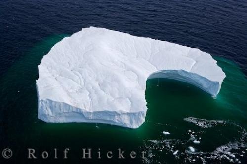
Large chunks of ice float away from a massive berg showing the results of what happens when the iceberg begins to melt. This can be because the iceberg has drifted into warmer waters and weather but can also be caused through Global Warming.
A large melting tabular iceberg off the Atlantic coast of Labrador! The topography of this flat topped berg shows ridges and depressions similar to that seen on land where water and ice has shaped and molded the landscape. The grooves on the surface of the ice are small streams of water (created from the melting ice on top of the iceberg) - these streams then form a waterfall as they cascade over the edge to the ocean below.
In 2008, there was a record number of icebergs reported seen in Iceberg Alley. While this is exciting for those wishing to see icebergs - it is perhaps not so thrilling for the environment as it could be the results of global warming.
This iceberg will have spent approximately 2 years travelling ... from the time the ice calved from the Greenland Glacier to the time it reached Iceberg Alley off the coast of Newfoundland and Labrador. ... continue below the picture...
Melting Ice Berg Results Global Warming Atlantic

Pictures from photo gallery "Waterfall Pictures"
This picture is part of the photo album "Ocean Pictures" - there are more beautiful images waiting for you.
Related stock photo galleries, pictures & travel ideas:
Melting Ice Berg Results Global Warming Atlantic
... In that time, having been bound by pack ice then being released to travel on the ocean currents, the berg has been subjected to and shaped by wind and waves. Although this annual parade of icebergs has existed for centuries, there are mounting concerns about the melting ice in Greenland which have been directly linked as being the result of global Warming.
Aerial view of a melting iceberg in the Strait of Belle Isle, Southern Labrador, Labrador, Newfoundland Labrador, Canada.
Technical Information:
I photographed this photo with the digital SLR camera model Canon EOS-1Ds Mark II, aperture of f/6.3, exposure time of 1/400 sec. on ISO 200, as always I used a original Canon Lens, the focus lenght for this picture was 54mm.
Large chunks of ice float away from a massive berg showing the results of what happens when the iceberg begins to melt. This can be because the iceberg has drifted into warmer waters and weather but can also be caused through Global Warming.
