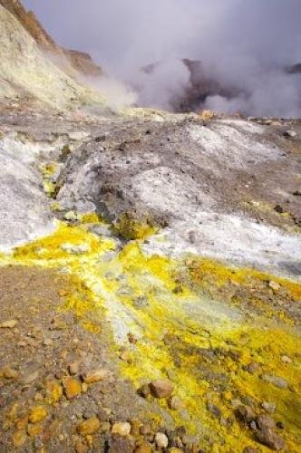
Photo: Volcano Landscape White Island North Island New Zealand
Sulphur and other minerals can be seen on the landscape of White Island; an active volcano in the Bay of Plenty on the East Coast of the North Island in gorgeous New Zealand. This is an active composite volcano which has occasional eruptions.
This island is part of the Olive Island chain, located off the coast of New Zealand, and this one is the largest of the four. It is only about two kilometres in diametre however, but the peak is about 321 metres above sea level. It is also known by the Maori name of Whakaari.
Sulphur mining was attempted on this island, but the efforts were abandoned in 1914, after 10 people died in a landslide which engulfed the sulphur mines. Now the area is used for tourism and scientific research.
The volcano on this island is New Zealand's only active marine volcano, and its eruptions have caused lava flows and plumes of ash to escape. Some scientists call this the most accessible volcano on earth, but it is constantly monitored by cameras and various machines that monitor ground activity, as the volcano could errupt again at any moment. ... continue below the picture...
Volcano Landscape White Island North Island New Zealand

of Plenty, East Coast, North Island, New Zealand.
Pictures from photo gallery "Grizzly Bear Pictures"
Related stock photo galleries, pictures & travel ideas:
Volcano Landscape White Island North Island New Zealand
... On a scale of 1 to 5, the island is usually on the alert level of 1 to 2 for potential eruptions. The last eruption was on July 27, 2000, when the whole island was covered in mud, volcanic rocks, and a new crater emerged.
Landscape of White Island, an active volcano, with sulphur and various minerals, Bay of Plenty, East Coast, North Island, New Zealand.
Technical Information:
I photographed this photo with the digital SLR camera model Canon EOS-1Ds Mark II, aperture of f/10.0, exposure time of 1/125 sec. on ISO 100, as always I used a original Canon Lens, the focus lenght for this picture was 21mm.
Sulphur and other minerals can be seen on the landscape of White Island; an active volcano in the Bay of Plenty on the East Coast of the North Island in gorgeous New Zealand. This is an active composite volcano which has occasional eruptions.
