Pictures Of Agawa Bay Lake Superior
Photo gallery for pictures of Agawa Bay in Lake Superior Provincial Park, Ontario, photographed by professional photographer Rolf Hicker. (There are 15 photos in this photo gallery.)
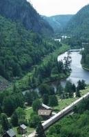
Ninety kilometers (56 miles) northwest of Sault Ste Marie, Ontario lies Agawa Bay on the northern shore of Lake Superior, the largest, deepest and coldest of the Great Lakes in Canada.
The name Agawa is Ojibwa for "Sacred Place" and this entire area was deemed to be sacred by them. Pictographs painted with an iron and grease based paint on white crystalline granite form one of the most famous pictograph sites in Canada and lie not far from this beach in the photograph. Abstract figures of lines and circles, real and mythical animals and canoes have been drawn by the Ojibwa perhaps commemorating a war expedition; most of the drawings on the rocks date from the 17th and 18th centuries.
Part of the Lake Superior Provincial Park, Agawa Bay features a campground which spills out onto a sandy beach and is the perfect place to watch as the sun sets on another day.
Interesting Photo galleries related to "Pictures of Agawa Bay Lake Superior"